Watching the Arctic Thaw in Fast-forward
The frozen permafrost in the Arctic is thawing on an alarming scale
The frozen permafrost in the Arctic is thawing on an alarming scale. By analysing an annual record of satellite images, researchers at the Alfred Wegener Institute have now confirmed these findings: thermokarst lakes in Alaska are draining one by one because warmer and wetter conditions cause deeper thaw, effectively weakening frozen ground as a barrier around lakes. In the season 2017/2018, lake drainage was observed on a scale that model outputs didn’t expect until the end of the century.
The Arctic is warming more quickly than almost any other region on Earth as a result of climate change. One of the better known: the continually shrinking summer sea-ice extent in the Arctic. But global warming is also leaving its mark on terrestrial permafrost. For several years, permafrost regions have been thawing more and more intensively in North America, Scandinavia and Siberia – e.g. in the extreme northwest of Alaska. Permafrost is soil that has remained permanently frozen to depths of up to several hundred metres, often since the last glacial period, roughly 20,000 years ago, or in some cases even longer.
The permafrost regions near the city of Kotzebue, Alaska, are dotted with hundreds of thaw lakes. These are formed when the permafrost soils begin to thaw and subside. Meltwater from the soil or from the winter snowfall and summer rainfall collects in the hollows. Some are several thousand years old and were formed since the end of the last glacial period. But in recent years, the lake landscape has changed due to more frequent relatively mild winters there. In summer, the permafrost soils thaw extensively and they don’t completely refreeze in winter, which means that the lakes’ shores become unstable and collapse, causing water to drain from the lakes. Researchers from the Alfred Wegener Institute, Helmholtz Centre for Polar and Marine Research (AWI) observed a particularly extreme example of this in the seasons 2017 and 2018: within a year, more lakes drained than ever before – roughly 190 in total. “The scale shocked us,” says AWI geographer Ingmar Nitze. “The winter 2017/2018 was extremely wet and warm. Conditions were similar to those our climate models predict will be normal by the end of this century. In a way, we caught a glimpse of the future. By then, widespread lake drainage will have reached a catastrophic scale.”

As Nitze and his co-authors report in the journal The Cryosphere, the mean temperature in the 2017/2018 season was circa five degrees Celsius above the long-term average. In Kotzebue, the winter temperature is usually about minus 20 degrees – but in that year the temperature was 10 to 20 degrees higher on several days. Furthermore, as a result of the moist air, there was a significant amount of snow. Since snow insulates the soil against the cold air in winter, the active layer and upper permafrost that had partially thawed in summer did not refreeze sufficiently during this relatively mild winter. A chain of factors likely led to the drainage of the lakes, one of which was the fact that the permafrost around the shores had degraded, facilitating lateral drainage. In addition, the large amount of meltwater from the thawing snow masses increased the lake water levels. Making matters worse, the water was able to drain easily, cutting veritable flood channels through the thawed soil surface layer. “With a depth of one to three metres, the lakes are relatively shallow and so drain quickly,” explains Ingmar Nitze. Fortunately, since the region is sparsely populated, no major damage was done. But that’s not the point, adds the researcher. “This drainage event simply shows the extreme scale of warming and impacts to tundra and permafrost landscapes that we’ll see in the Arctic in the coming decades. But above all, it shows that extreme events won’t occur only at the end of the century, but are already taking place and will do so in the years to come.” This is a cause for concern, since it means that the ancient plant remains stored in the permafrost soils can become exposed and broken down by microbes. The carbon contained within the plants is then released as carbon dioxide or methane, which exacerbates the greenhouse effect – a vicious circle.
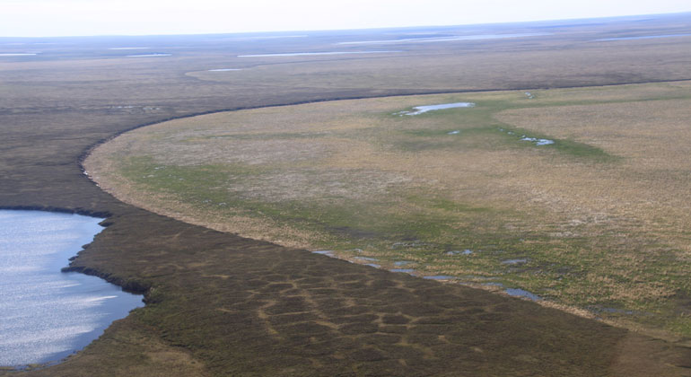
For their study, Ingmar Nitze and his colleagues evaluated satellite images of the region surrounding Kotzebue and northwestern Alaska. In the pictures, the full and drained lakes can be easily distinguished. It is also clear when the lakes begin to drain. Winter 2017/2018 was the warmest in the region since continuous records began at the Kotzebue station in 1949. Accordingly, the experts had expected several lakes to drain. But they hadn’t expected it to happen on this scale. “In the mild years 2005 and 2006, several lakes drained – but this time there were twice as many.” And that’s worrying, the experts warn, because at the same time it means the permafrost’s potential to preserve large amounts of carbon is shrinking at an alarming rate.
- Time-series animation of PlanetScope satellite images of a lake drainage in northwestern Alaska in 2018. (Planet Team (2017). Planet Application Program Interface: In Space for Life on Earth. San Francisco, CA.https://api.planet.com.)
- Ingmar Nitze, Sarah Cooley, Claude Duguay, Benjamin M. Jones, Guido Grosse: The catastrophic thermokarst lake drainage events of 2018 in northwestern Alaska: fast-forward into the future. TheCryosphere 14, 4279-4297, DOI: 10.5194/tc-14-4279-2020, 2020.


